Story of Chongqing's Placenames
Chongqing, a city of long history, is home to plenty of historical sites and ruins. Many streets and lanes here are centuries old and take their names from stories known to few.
Wanglongmen: From an ancient legend
Wanglongmen, literally the door where the dragon looks up, is a special place among the streets in Yuzhong District, as it is named a door, yet it has no real door. Among the 17 city walls in Chongqing’s history, there’s no gate called Wanglongmen. In fact, Wanglongmen gained its name from an ancient legend.

The site of the cable car in Wanglongmen
Once upon a time, there was no dock at Wanglongmen, only a creek meandering from Jinbi Mountain and emptying into the Yangtze River here. In the summer, a little dragon came here and used his body to form a dam against the flood outside the city. Every August 15 in the lunar calendar, the little dragon would miss his hometown and look up to the east, longing for the dragon door to open for him to see his family from the East China Sea. In the due east, two rocks on the other side of the Yangtze River are reflected in the water, forming a dragon gate to relieve the little dragon’s homesickness. Hence, the place where the dragon lay was named Wanglongmen, and the opposite bank was named Longmenhao.
Hongyadong: Waterfall or sunset
In the Southern Song Dynasty, official Peng Daya built Hongya Gate, Qiansi Gate, and Taiping Gate to fortify Chongqing City. That means today’s Hongyadong (Hongya Cave/洪崖洞), Qiansimen (literally Qiansi Gate), and Taipingmen (Taiping Gate) have a history of at least 800 years.
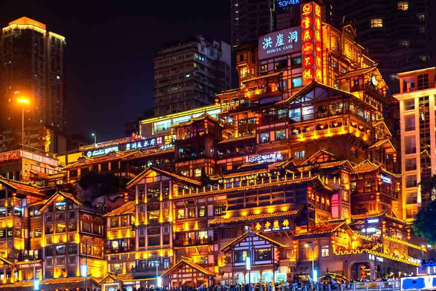
The night skyline of Hongyadong
The name Hongyamen came from Hongyadong. Between Linjiangmen and Qiansimen towers a cliff, where the city wall and Hongya Gate were built. At the right bottom of Hongyamen under the cliff lies a cave, called Hongyadong. A traditional story said the verdant plants on the cliffside formed a waterfall on rainstorm days, and the cave was therefore named “Hong (洪, referring to a large amount of water).” Some others think the rainfall here is not significant enough to form a waterfall, so they assume that the place was formerly named “Hong (红, meaning red),” a homophone for Hong (洪) because rocks in Chongqing often turn red under the sunset.
Fotuguan: Tiger
In ancient times, Chongqing was bordered by land in the west and by rivers in the other directions. Three passes were built to protect the people, at the west access into the city: Fotu Pass (Fotuguan), Erlang Pass (Erlangguan), and Longdong Pass (Longdongguan).

Fotuguan
Fotuguan, or Futuguan, obtained its name over a thousand years ago. Fotu (佛图) and Futu (浮图) both originated from the Chu dialect “Wutu (於菟),” which means tiger. Therefore, the place is also referred to as Wutuguan, i.e., the Tiger Pass. Fotuguan looks like a tiger guard. Standing on the ridge of Eling Mountain and surrounded by sheer precipices, it is a pass easy to hold but hard to attack. When the people of Ba (a state in today’s Sichuan and Chongqing in the Zhou Dynasty) went westward along the Yangtze River to Chongqing, they named the pass Wutu, which is written in their language and similar to the Chu dialect.
Where are the “Pos (literally slopes)”?
Shibanpo (literally stone slopes) refers to the hills around Shihuang Tunnel. People used to exploit dressed stones and slab stones at the rocky slopes. After 1936, the place was increasingly populated and became a street, hence the name Shibanpo Central Street; in 1968, it was renamed Dengta Street during the Great Cultural Revolution; in 1972, it regained the original name. Wangjiapo (literally Wang’s slopes) refers to the slopes under Seven-Opening Bridge (Qikong Qiao) on Changjiang 1st Road. In the Qing Dynasty, a man and his nephew surnamed Wang from Jiangxi came here to open up the wasteland, hence the name Wangjiapo.
Disappeared “sandbank”
Liziba is located at half of a hill facing toward the Jialing River and against Fotuguan. As there was a dense plum forest, people called it Liziba or the Sandbank of Plum Forest.
It lies on the most extensive sandbank, formed by the natural alluviation, by the left bank of the Yangtze River in Yuzhong District. The sandbank stretches from 1.2 to 1.8 kilometers from the east to the west and is about 0.6 kilometers wide from the south to the north. The earliest record of the Shanhuba is from the Shu Han period (221–263).

Liziba Station
At the space between the Lianglukou and the Yangtze River, it is interesting that there once situated three sites called Caiyuanba, specifically at today’s Caiyuanba, Haitangxi, and Yangjiaping. In the past days, when the old Chongqing hadn’t developed so well, the urban regions had blocks of croplands. Today, after two sites of Caiyuanba have disappeared, the name exclusively belongs to the Caiyuanba Railway Station. The appearance of the physical sandbank also faded away with the city’s development.
Location of the “ground”
This ground is located near today’s Second Changjiang Road, borders on Yuzhou Road and Xiaojiawan, and has Xiejiawan to the south and Shiqiaopu to the west. In the old days, the post road stretched from the downtown, bypassed Fotuguan, and reached Daping. Seven decades ago, Huang Tianqi, lived in Erlang, had to take the post road to the school in the downtown. At that time, there were pack horses, porters, huagan (bamboo-made stretcher), postmen, merchants, passers-by, and others coming and leaving on the road. It was the only officially-built land road connecting Chongqing and Chengdu.
Qixinggang: Not hummock but water vats
“The road name Qixinggang doesn’t originate from hummock but a set of water vats.” Fire disasters frequently happened in Chongqing. Lacking tap water, people had to prepare stone vats, generally in the rectangle shape, to store fire water in case of emergency. The vats, carved with “preparedness averts peril,” were called fire extinction ponds. The Qixinggang, or Seven Star Vats, were positioned into the shape of the Big Dipper.

Qixinggang
Thus the area named Qixinggang had no hummock but such well-positioned vats. People deliberately placed the vat set at Tongyuan Gate, hoping to suppress the Nanji Gate (representing the fire) with the Big Dipper (representing the water) according to the traditional theory of the Five Elements in ancient China. No document has been found to show when the seven vats were initially placed there. During the 1920s, when Chongqing was preparing to build itself into a formal city, it opened new urban regions, constructed new roads, and dismantled old city walls. Qixinggang was among those that had been removed, leaving the name to call the road.
Zhongshan First Road, formerly Zhong First Road, renamed in honor of Sun Yat-sen
Starting from the intersection of Minsheng Road and Jintang Street and ending at Zengjiayan of Shangqing Temple, the Zhongshan First/Second/Third/Fourth Roads were named Qixinggang, Huangjia Yakou, Guanyinyan, Shang Luojiawan, Lianglukou, Mengyuan, Yanghuaxi, Sanyicun, Meizhunxiao Street, Shangqing Temple, etc., in related sections. After its construction in 1931, they were renamed Zhongshan First/Second/Third/Fourth Roads, signifying the primary roads of the central region.

Zhongshan Forth Road
In 1937, to commemorate Sun Yat-sen (Sun Zhongshan in Chinese pinyin), the roads got new names: Zhongshan First Road from the west end of Minsheng Road to Guanyinyan, Zhongshan Second Road from Guanyinyan to Lianglukou, Zhongshan Third Road from Lianglukou to Shangqing Temple, and Zhongshan Fourth Road from Shangqing Temple to Shang Zengjiayan, collectively called the Zhongshan Road.
Wusi Road & Bayi Road: Originated from the War of Resistance
Today’s Wusi Road was called Jianjiaqiao (Jianjia Bridge), and it was reconstructed and obtained the name Wusi after the Bombing of Chongqing. Bayi Road shares a similar origin with Wusi Road. In 1937, it consisted of the sections of Bailongchi, Leizu Temple, Dayanggou, Mihua Street, Zhongying Street, which were combined after the Bombing of Chongqing. In 1968, it was officially named Bayi Road.
Shibati: Not 18 stairs but 18 layers
The region Shibati once experienced prosperity with lots of Chongqing citizens. In the Qing Dynasty, a stone-stair road was built to connect the upper and lower parts of the downtown. At the north end, there are over 200 stone stairs in 18 layers, winning the region the name Shibati (literally 18 layers of stairs).
 Related Stories